Mud Creek: Documenting a Disaster
In 2014, high atop the northern California volcanic mountain of Mt. Shasta, a glacial dam broke free. The resulting washout destroyed the Pilgrim Creek Road bridge and began a series of mud and debris flows forcing a mountain community to face years of setbacks and make accessibility a challenging act of endurance.

At the time of me writing this report, the good news is that Pilgrim Creek Road was finally cleared and reopened in the fall of 2023. There is still uncertainty with how conditions will play out through the winter in what has been forecasted as an “El Nino” year. While the residents brace for what may or may not happen, the mountain and mother nature seem once again in control and only time and the weather will tell what’s in store. In the meantime, I wanted to compile my documentation of this ongoing dilemma that had nonstop setbacks and challenges, all that the Mount Shasta Forest Subdivision and it’s residents dealing with the brunt of.
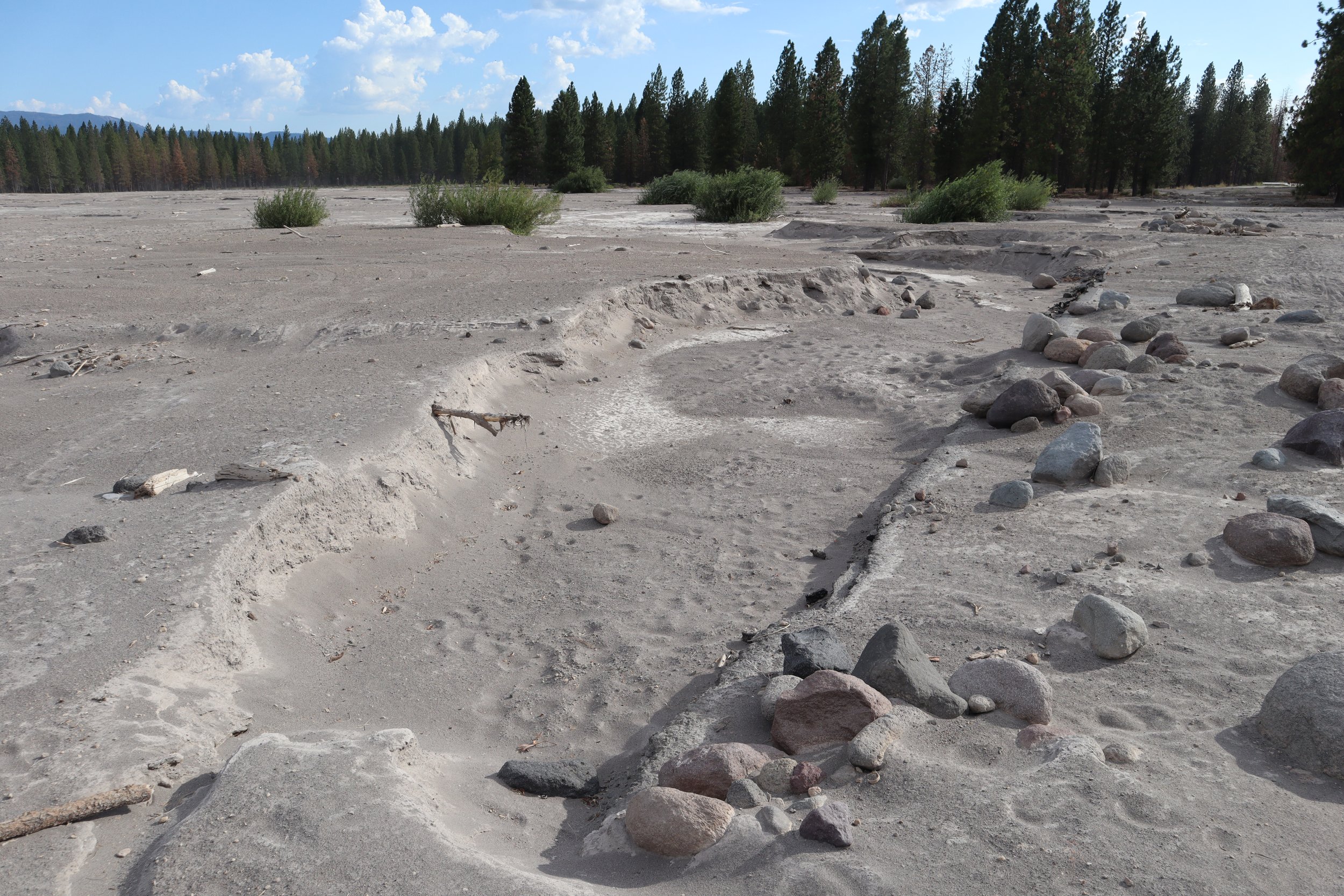
When the initial event happened in 2014, the road was cleared and the bridge was re-engineered and many thought or had hoped it was a one time deal. Following a record drought and a drop in year-round snow pack, the calamity happened again. On July 27th, 2021, a glacial lake opened and raced down the mountain. Despite the reinforcement of the Pilgrim Creek Bridge, mother nature and water in particular, had its way of carving its own path. The resulting mud flow crippled the roadway and brought down even more debris down into the surrounding meadow than the first event. The gallery below, catalogs the changing trajectory of Mud Creek and the surrounding debris that will forever change this area.


As the days, weather, and conditions changed so did where the creek was flowing. The re-engineered bridge had done it’s job and stayed put, even while the creek meandered to the left and right of it, and rarely back underneath it. The changing flows, reminded me of visiting the beach at different tides, each time you went, everything was always different. The landscape felt lunar and sometimes otherworldly as dust devils danced across the flats while open range cows and even horses patrolled the area. There was something to watching this all unfold as you parked and walked along this stretch of highway that hadn’t been use to this non-human activity in many decades.
Further up the road, the flow of the creek, the continued erosion of glacial silt, and various weather events had other consequences that ended up changing local infrastructure. One source of the town of McCloud’s water supply, had even been threatened multiple times. This stretch of pipe that crossed the creek, at one point was well above the waterline, and was completely unfathomable that it would’ve ever been in reach. Despite large-scale civil engineering efforts to dig out the channels and create berms to minimize the continued threat of flooding, the power of water continued to be in control of the situation.

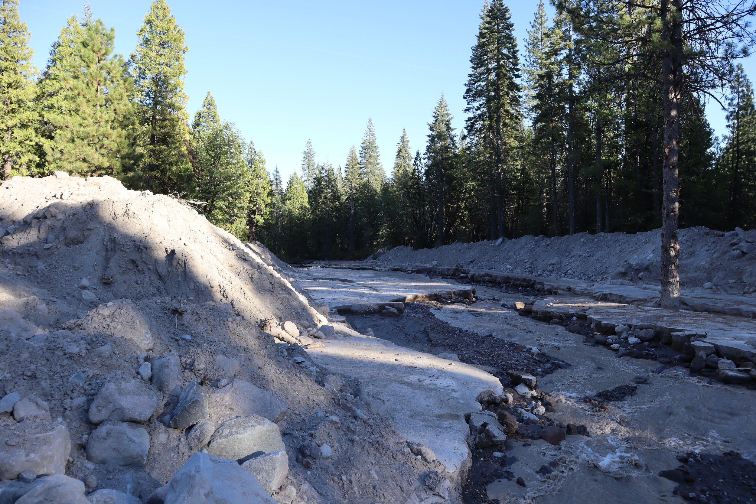


One such event was finally the last straw, another heavy rain storm, and tons of mud, water, and debris almost could have destroyed the pipe and potentially contaminated the town’s water supply. The resulting flow once again moved the earth as if it were nothing. The massive berms were no match, and rocks and massive boulders were once again pushed to clearings and redistributed. The failure of the berms and the almost catastrophe of the water supply pipe forced the town of McCloud to intervene and a massive earth-moving operation commenced to dig out the channel and completely bury the water supply pipe. To complete this endeavor required re-directing the creek so the work could be completed over several weeks in the fall of 2022.
So where did the Debris come from?
One of the most common happenings in many places, is how information travels, where it comes from, and how it changes from one person to the next. What was passed on from official reports, neighbors, and other people in the area consisted of the consensus that a melting ice damn in the Mud Creek Glacier high on top of Mount Shasta gave way sending cascading water down the mountain, over Mud Creek Falls, and onward to the destruction further down the creek’s path. Although this is what can accurately be assumed, not much was mentioned on where the actual debris was coming from. This would require detailed photographic and satellite evidence to determine the sources of the grayish glacial silt. This journey began over a span of a few years when I first ascended Clear Creek Trailhead in the Fall of 2018 and began documenting changes high above.

Mud Creek Glacier, November 2018 (Left) & September 2021 (Right)
One thing is sure, many of the glaciers on Mount Shasta, just like many around the world are receding. Even with high snow fall winters, glaciers need sustained precipitation and cold to repair or accumulate. There’s a reason why most glaciers around the world remain from the last ice age, the period’s sustained cold, precipitation, and a lack of hot summers of seasonal melting, grew these stone carving ice giants. The biggest factor in this receding are warmer temperatures, especially hotter summers. So between heavy precipitation or an ice dam failing and releasing stored water within the glacier, we have the cause, but the debris is not so clear. the biggest piece of evidence that suggests that the debris came from further down the mountain is evident based on the lack of certain features higher on the mountain.


The above gallery takes closer a look at Mud Creek Falls, and the path that water travels down the slopes from the glacier. One major thing that is absent from this path is consistent destruction from such an event. There is vegetation that dots the slopes (trees, shrubs, grasses), which more than likely would’ve been wiped clean away in a major slide on this part of the mountain. This suggest that although a large amount of water rushed down this channel and over the falls, it was not enough to destabilize this upper portion. If it had, the amount of visible destruction would be more present. In order to find the source of the debris, we’ll have to travel further down the creek system, but not by much.


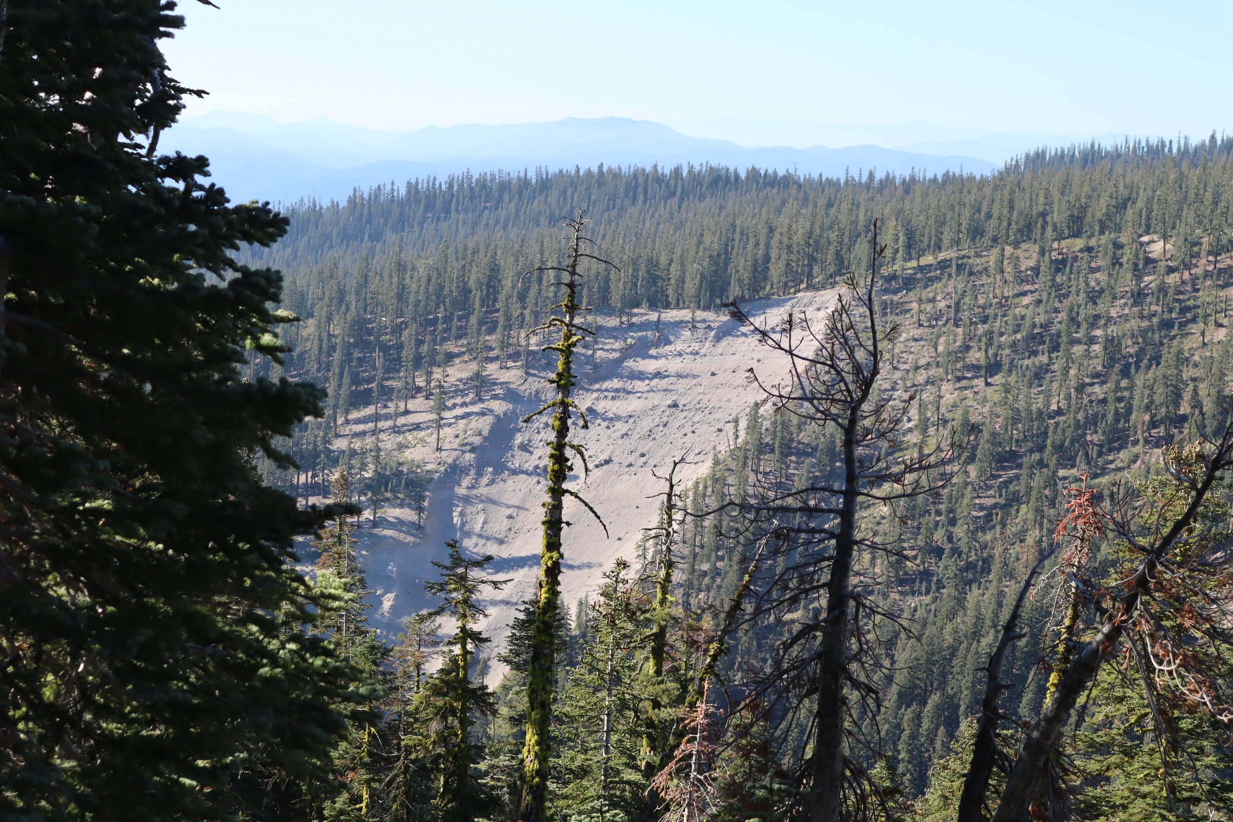
You can imagine my intrigue when I first noticed this apparent landslide (Gallery Above), across the valley from the Clear Creek Trail. This slide was easy enough to identify due to the surrounding topography and the sudden lack of vegetation and trees. The most important observation was the grayish sandy-silty material. Not only did this match the color of the silt deposited at the Mud Creek Meadows down at Pilgrim Creek Road but the exposed hillside showed an important geological feature about the story of Mount Shasta. Water is the great carver, whether or not in the form of glacial ice, a stream or creek, or the erosion that takes place over long periods of time with precipitation and storm runoff.
As the hard igneous rock filled with composite materials weathers over time, it is broken down smaller and smaller, and eventually those materials are deposited wherever the water carries it. Over a millennia those deposits become mounds, and those mounds become hillsides. Vegetation and trees grow, and over time these hillsides stabilize but they do not solidify. Solidification would require a metamorphic change fusing the materials together through temperature or pressure. Metamorphic rock can be found in many places, but this change tends to happen deep underground. Without this reaction, these deposited materials have no way of fusing on a molecular scale and in essence are never locked together, only kept together by gravity and the immense weight of the layers above. All it takes for a landslide to occur, is the destabilization of a region due to vegetation loss, the over-saturation of the area, and a clear path for the materials to move to either down hill or down river. This hill slide was the first piece of evidence of where the debris came from, but shockingly it was not the only source.

Thanks to satellite imagery from Google Earth and by finding the initial hill-slide evidence from the Clear Creek Trail Head ridge, the reality and the evidence becomes even more clearer. Following Mud Creek down from the glacier, at least five major slides are evident with several other minor slide areas also observable. Now, the shear amount of debris that has washed down the mountain makes a lot more sense. So what does this mean? It means that this phenomenon has the increased likelihood of repeating during heavy rain or flood events. Until each slide area stabilizes either through vegetation or after enough materials have washed out, this will be an ongoing occurrence. The worse case scenario would be a major slide event which could have devastating effects. Thankfully to date, none of these events have resulted in the loss of property or human life, but these areas will need to be closely observed for any slight or major changes, and precautions and early warning systems may need to be installed to give warning downstream in case another event happens.
The biggest impact of this whole debacle, has mostly been payed by the many year-round residents of the Mount Shasta Forest subdivision. The closure of Pilgrim Creek Road from 2021 to Fall 2023 forced residents, foresters, and logging trucks to take Esperanza road, which would now have to serve as the most direct way in and out of the division. This unpaved road would now take center stage in the daily lives of the people who were dependent on it to get in and out of the area. The conditions in the above video are from March of 2023 after an unseasonably amount of snow fall that caused many problems of its own for the people who call this place home.
Chewed up by snow, rain, logging trucks, and heavy travel, the 2 mile road became a hazard of potholes, ruts, and conditions requiring four wheel drive and a high clearance vehicle to avoid damage. This was the reality for people day in and day out, and the fact that no major medical emergency resulted in fatalities due to the extended travel time is a miracle. Although spring would finally come, the road conditions would in fact get worse from something that was supposed to make things better. Finally the road would be regraded, but this time a special rock was used in an effort to cut down on dust. The gravel was larger and unfortunately sharper which became the new hazard. Sharp rocks that over time and travel would come to the surface and pop vehicle tires. By the time Pilgrim Creek was finally cleared, well over 60 tires had been destroyed over the 2 mile surface. The residents just couldn’t seem to catch a break.